Size in Square Kilometres
722,961
Qualifying Species and Criteria
Sperm Whale – Physeter macrocephalus
Criterion A; B (2); C (2)
Criterion D (2) – Marine Mammal Diversity
Other Marine Mammal Species Documented
Balaenoptera musculus, Balaenoptera physalus, Delphinus delphis, Grampus griseus, Megaptera novaeangliae, Stenella coeruleoalba, Stenella frontalis
Summary
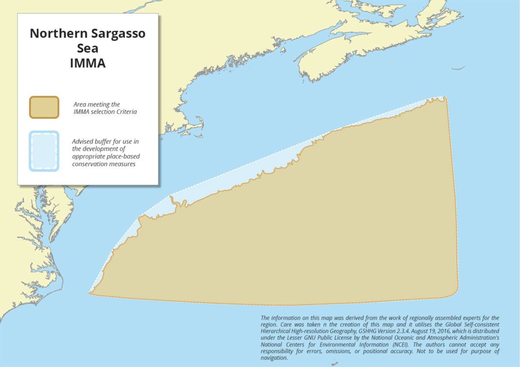
The Northern Sargasso Sea IMMA lies in the temperate western North Atlantic. It is located south of Nova Scotia, east of the northeastern states of the USA, and north of Bermuda, outside the continental shelf. Its waters are strongly influenced by the powerful Gulf Stream Current and are generally 3,000-4,000 m deep, although the area includes some of the New England Seamounts which rise to nearly 1,000m below the surface. The area has the world’s highest known densities of Vulnerable sperm whales (Physeter macrocephalus) presumably because it is a valuable feeding ground for the species. The area overlaps with the “Sargasso Sea” and “New England and Corner Rise Seamounts” EBSAs, as well as the US “Northeast Canyons and Seamounts Marine National Monument”.
Description of Qualifying Criteria
Criterion A – Species or Population Vulnerability
This IMMA encompasses important aggregations and feeding grounds for the sperm whale (Physeter macrocephalus), which is assessed as Vulnerable (Taylor. et al., 2019) on the IUCN Red List of Threatened Species, with data indicating a concerning decline in populations over time (Whitehead and Shin 2022). From an estimated pre-whaling global population of about 1,950,000, the species experienced a significant reduction to about 850,000 in 2022.
Criterion B – Distribution and Abundance
Sub-criterion B1 – Small and Resident Populations
Sub-criterion B2 – Aggregations
The density of sperm whales in the Sargasso Sea is among the highest globally (Wong 2012). During Wong’s (2012) acoustic surveys, the area between 600 and 660W had the highest proportion of detections per unit of effort compared to other areas in the Sargasso Sea. The western part of the area, off the US continental Shelf, has the highest estimated density of sperm whales of 16 studies around the world, about 0.0106 whales/km2 (Hayes et al. 2020; Palka 2020; Whitehead and Shin 2022). In the northern Sargasso Sea outside the US EEZ, Wong (2012) estimated a density of 0.0053 whales/km2, more than double the average global estimate of 0.0024 whales/km2 (Whitehead and Shin 2022). The reasons for this high density are not clear but likely include the Gulf Stream current interacting with the prominent New England seamount chain (Wong and Whitehead 2014).
Criterion C: Key Life Cycle Activities
Sub-criterion C1 – Reproductive Areas
Sub-criterion C2: Feeding Areas
Acoustic recordings (echolocation clicks and buzzes) as well as defecation rates show that sperm whales are foraging in the Northern Sargasso Sea (Wong 2012; Wong and Whitehead 2014).
Sub-criterion C3: Migration Routes
C3a – Whale Seasonal Migratory Route
C3b – Migration / Movement Area
Criterion D – Special Attributes
Sub-criterion D1 – Distinctiveness
Sub-criterion D2 – Diversity
Supporting Information
Hayes, H. S. A., Elizabeth, J., Katherine, M.-F. & E, R. P. US Atlantic and Gulf of Mexico Marine Mammal Stock Assessments—2019. NOAA Technical Memorandum NMFS-NE-264 (2020).
Palka, D. Cetacean abundance in the US Northwestern Atlantic Ocean: summer 2016. Northeast Fisheries Science Center Reference Document 20–05 (2020).
Taylor, B.L., Baird, R., Barlow, J., Dawson, S.M., Ford, J., Mead, J.G., Notarbartolo di Sciara, G., Wade, P. & Pitman, R.L. 2019. Physeter macrocephalus (amended version of 2008 assessment). The IUCN Red List of Threatened Species 2019: e.T41755A160983555. https://dx.doi.org/10.2305/IUCN.UK.2008.RLTS.T41755A160983555.en. Accessed on 29 March 2024.
Whitehead, H., and M. Shin. 2022. Current global population size, post-whaling trend and historical trajectory of sperm whales. Scientific Reports 12: 19468.
Wong, S.N.P. 2012. A pelagic paradox: The ecology of a top predator in an oceanic desert. PhD thesis, Dalhousie University.
Wong, S.N.P., and H. Whitehead. 2014. Seasonal occurrence of sperm whales (Physeter macrocephalus) around Kelvin Seamount in the Sargasso Sea in relation to oceanographic processes. Deep Sea Research I 91: 10-16.
Downloads
Download the full account of the Northern Sargasso Sea IMMA using the Brochure button below:
To make a request to download the GIS Layer (shapefile and/or geojson) for the Northern Sargasso Sea IMMA please complete the following Contact Form:


